Questions addressed in this theme include:
- What improvements are obtainable in satellite rainfall estimation of mountainous heavy precipitation events and how those improvements impact flood modelling?
- Specifically, how to apply error corrections of satellite rainfall products in absence of ground reference data?
- What kind of hydrologic modeling, or parameter estimation procedure, is most appropriate in the case of satellite rainfall forcing data considering satellite data uncertainty and spatial resolution.
An extensive evaluation of nine global-scale high-resolution satellite-based rainfall products is performed using a minimum of 6 years (within the period of 2000–13) of reference rainfall data derived from rain gauge networks in nine mountainous regions across the globe.
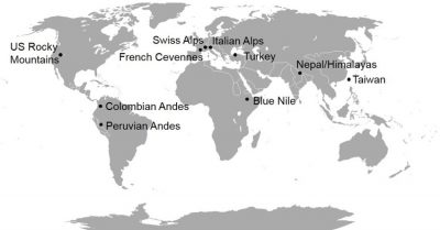
Figure 1. Geographic locations of the study regions (Derin et al. 2016)
Derin et al. (2018) evaluate six global-scale high-resolution satellite-based precipitation products in terms of extreme values (>90th quantile) using more than six years (within the period 2000-2015) of reference precipitation data from rain gauge networks over nine mountainous regions.
Researchers:
References:
[1] Derin, Y., E. N. Anagnostou, A. Berne, M. Borga, B. Boudevillain, W. Buytaert, C-H. Chang, G. Delrieu, Y. Hong, Y. C. Hsu, W. Lavado-Casimiro, B. Manz, S. Moges, E. I. Nikolopoulos, D. Sahlu, F. Salerno, J-P. Rodrigues-Sanchez, H. J. Vergera, and K. K. Yilmaz, 2016: Multi-regional satellite precipitation products evaluation over complex terrain. J. Hydrometeor., 17, 1817-1836.
[2] Derin, Y, E. Nikolopoulos and M. N. Anagnostou., 2018: Retrieving Extreme Precipitation with Multiple Satellite-based Precipitation Products, Extreme Hydroclimatic Events and Multivariate Hazards in a Changing Climate, Elsevier